> For the complete documentation index, see [llms.txt](https://docs.mapeo.app/llms.txt). Markdown versions of documentation pages are available by appending `.md` to page URLs; this page is available as [Markdown](https://docs.mapeo.app/espanol/guia-de-referencia-completa/glosario-y-hojas-de-referencia-rapida/descripcion-general-de-la-pantalla-del-modo-territorio-de-mapeo-desktop.md).
# Descripción general de la pantalla del modo Territorio de Mapeo Desktop
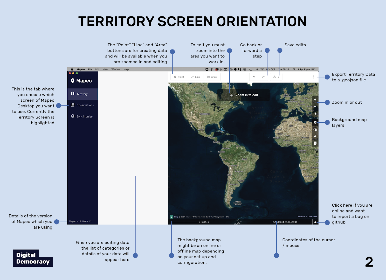
***(Clockwise rotation from left to right):***
* On the **Mapeo modes** panel, you can select the mode of  Mapeo Desktop that you want to access. Here, the **Territory** mode is highlighted.
* The **Point**, **Line**, and **Area** buttons are for creating data and will be available when you are sufficiently zoomed in for editing.
* To edit, you must zoom into the area where you want to create data.
* Use the
Mapeo Desktop that you want to access. Here, the **Territory** mode is highlighted.
* The **Point**, **Line**, and **Area** buttons are for creating data and will be available when you are sufficiently zoomed in for editing.
* To edit, you must zoom into the area where you want to create data.
* Use the  **Undo** and
  **Redo** buttons to go back or forward a step.
*
**Redo** buttons to go back or forward a step.
*  **Save** your edits.
*
**Save** your edits.
*  **Export** territory data to a `.GeoJSON` file.
* **+ Zoom in** or **+ Zoom out** on the map.
* Use the
**Export** territory data to a `.GeoJSON` file.
* **+ Zoom in** or **+ Zoom out** on the map.
* Use the  **Background** map window to select background map layers.
* The **Map Data** window can be used to turn map layers on and off on the map.
* The **Issues** window shows you if any of your current features being edited have any issues, such as a missing category.
* Click
**Background** map window to select background map layers.
* The **Map Data** window can be used to turn map layers on and off on the map.
* The **Issues** window shows you if any of your current features being edited have any issues, such as a missing category.
* Click  **Bug report** if you are online and want to report a bug on Github.
* The spatial coordinates at the location of the cursor / mouse.
* The background map might be an online or offline map, depending on your set-up and configuration.
* When you are editing data, the list of categories or details of your data will appear here.
* Details of the version of Mapeo which you are using.
**Bug report** if you are online and want to report a bug on Github.
* The spatial coordinates at the location of the cursor / mouse.
* The background map might be an online or offline map, depending on your set-up and configuration.
* When you are editing data, the list of categories or details of your data will appear here.
* Details of the version of Mapeo which you are using.